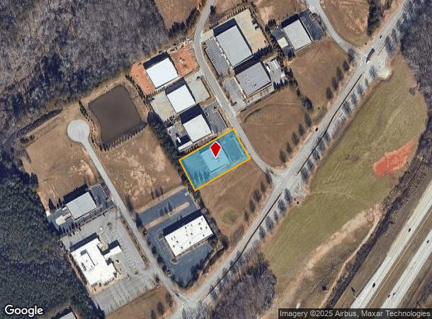
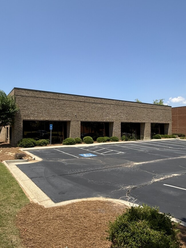
Property Record
4135 Industry Way, Flowery Branch, GA 30542


Current Lease Availabilities
NEARBY LISTINGS FOR SALE OR LEASE
Property Detail
4135 Industry Way
Gainesville, GA
Precision Stoneworks Inc Surv
08-00069-01-025
INDUSTRIAL WAY
Industrialgeneral
Hall
X
Georgia
13139C0284G
69
2024
1.03 AC
2024
I-985/Gainesville
001404
Atlanta
9,712 SF
DEMOGRAPHICS near 4135 Industry Way
1 Mile
3 Mile
5 Mile
2024 Total Population
1,987
32,223
74,132
2029 Population
2,311
36,378
83,002
Pop Growth 2024-2029
+ 16.31%
+ 12.89%
+ 11.97%
Average Age
37
39
39
2024 Total Households
663
11,887
26,122
HH Growth 2024-2029
+ 16.29%
+ 12.80%
+ 11.96%
Median Household Inc
$62,576
$69,307
$73,112
Avg Household Size
2.90
2.70
2.80
2024 Avg HH Vehicles
2.00
2.00
2.00
Median Home Value
$265,384
$263,412
$277,747
Median Year Built
2002
2000
1999
Nearby Places
- Restaurants
- Banks
- Shops
- Fitness
- Groceries
PUBLIC TRANSPORTATION
COMMUTER RAIL
Gainesville Amtrak Station (Crescent - Amtrak)
DRIVE
WALK
Distance
Gainesville Amtrak Station (Crescent - Amtrak)
13 min
9.2 mi
Freight Ports
Georgia Ports - Savannah
DRIVE
WALK
Distance
Georgia Ports - Savannah
323 min
254.5 mi
Nearby Properties
Address
Land Use
TOTAL SIZE
Lot Size
Zoning
Address
Land Use
TOTAL SIZE
Lot Size
Zoning
5,760 SF
38.07 AC
R-III
Address
Land Use
TOTAL SIZE
Lot Size
Zoning
85,900 SF
25.29 AC
H-B
Address
Land Use
TOTAL SIZE
Lot Size
Zoning
656,200 SF
70.29 AC
M-1
Address
Land Use
TOTAL SIZE
Lot Size
Zoning
102,060 SF
31.90 AC
R-III/H-B
Address
Land Use
TOTAL SIZE
Lot Size
Zoning
150,738 SF
43.34 AC
M-1
Address
Land Use
TOTAL SIZE
Lot Size
Zoning
164,815 SF
29.93 AC
R-IV
Address
Land Use
TOTAL SIZE
Lot Size
Zoning
92,448 SF
24.25 AC
PUD
Address
Land Use
TOTAL SIZE
Lot Size
Zoning
342,720 SF
22.95 AC
PUD
Address
Land Use
TOTAL SIZE
Lot Size
Zoning
144,744 SF
35.47 AC
C-II
Address
Land Use
TOTAL SIZE
Lot Size
Zoning
447,120 SF
35 AC
M-I
Address
Land Use
TOTAL SIZE
Lot Size
Zoning
4,511 SF
15.85 AC
PUD
Address
Land Use
TOTAL SIZE
Lot Size
Zoning
3,881 SF
27.86 AC
R-IV
Address
Land Use
TOTAL SIZE
Lot Size
Zoning
174,720 SF
50.23 AC
M-II
Address
Land Use
TOTAL SIZE
Lot Size
Zoning
112,308 SF
37.83 AC
M-1
Address
Land Use
TOTAL SIZE
Lot Size
Zoning
104,340 SF
42.22 AC
INST
Address
Land Use
TOTAL SIZE
Lot Size
Zoning
8,193 SF
32.02 AC
R-4
Address
Land Use
TOTAL SIZE
Lot Size
Zoning
351,550 SF
26.91 AC
M-II
Address
Land Use
TOTAL SIZE
Lot Size
Zoning
225,378 SF
24.42 AC
M-1
Address
Land Use
TOTAL SIZE
Lot Size
Zoning
440,001 SF
21.75 AC
M-I
Address
Land Use
TOTAL SIZE
Lot Size
Zoning
23,052 SF
6.99 AC
PRD
Address
Land Use
TOTAL SIZE
Lot Size
Zoning
304,844 SF
37.58 AC
M-2
Address
Land Use
TOTAL SIZE
Lot Size
Zoning
3,195 SF
80.04 AC
AR-III
Address
Land Use
TOTAL SIZE
Lot Size
Zoning
515,468 SF
92 AC
I-I
Address
Land Use
TOTAL SIZE
Lot Size
Zoning
213,480 SF
13.16 AC
M-I
Address
Land Use
TOTAL SIZE
Lot Size
Zoning
201,322 SF
10 AC
M-I
Address
Land Use
TOTAL SIZE
Lot Size
Zoning
440,000 SF
15.60 AC
M-I
Address
Land Use
TOTAL SIZE
Lot Size
Zoning
58.61 AC
AR-III
Address
Land Use
TOTAL SIZE
Lot Size
Zoning
141.54 AC
R-I
Address
Land Use
TOTAL SIZE
Lot Size
Zoning
87,714 SF
18.98 AC
C-II
Address
Land Use
TOTAL SIZE
Lot Size
Zoning
148,068 SF
31.65 AC
M-I
The World's #1 Commercial Real Estate Marketplace
Connect with us
© 2025 CoStar Group
The information above has been obtained from sources believed reliable. While we do not doubt its accuracy we have not verified it and make no guarantee, warranty or representation about it. It is your responsibility to independently confirm its accuracy and completeness. Any projections, opinions, assumptions, or estimates used are for example only and do not represent the current or future performance of the property. The value of this transaction to you depends on tax and other factors which should be evaluated by your tax, financial, and legal advisors. You and your advisors should conduct a careful, independent investigation of the property to determine to your satisfaction the suitability of the property for your needs.